
The sky often gives us clues about the weather to come. One common but often overlooked sign is cirrostratus clouds . These thin, almost transparent clouds often appear like a white blanket stretching across the sky. While beautiful, cirrostratus clouds can actually be an early sign of rain within the next 24 hours .
This article will discuss what cirrostratus clouds are, their characteristics, why they can be a sign of rain, and simple tips for recognizing them.
What Are Cirrostratus Clouds?
Cirrostratus clouds are a type of high cloud that forms in the troposphere, typically at altitudes of 6,000–13,000 meters above Earth's surface. These clouds are composed of extremely fine ice crystals , making them appear thin and transparent.
The name “cirrostratus” comes from Latin: cirrus means “clump” or “curly hair,” while stratus means “layer.” So, cirrostratus can be defined as a thin layer formed by clumps of clouds .
Characteristics of Cirrostratus Clouds
Cirrostratus clouds have several distinctive characteristics:
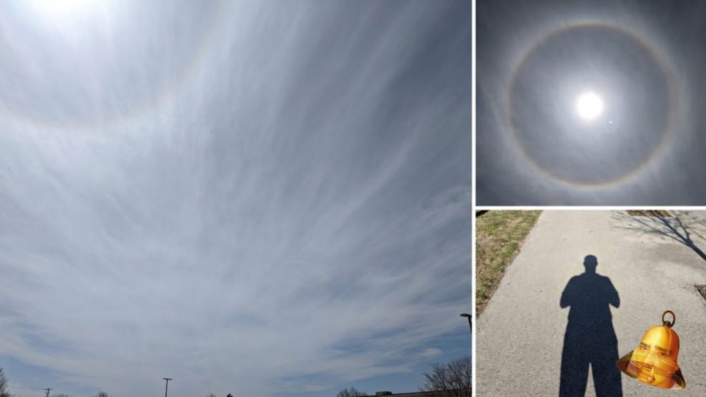
- Thin and transparent , it often covers the entire sky like a white sheet.
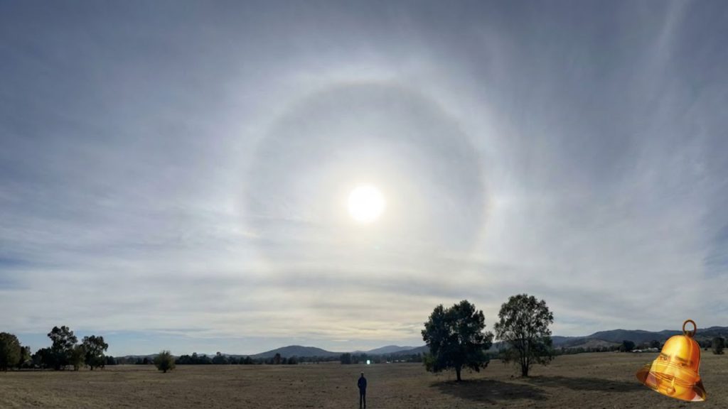
- Forming a halo around the sun or moon, because the ice crystals in it refract light.
- It does not produce direct rain , but usually indicates the presence of a warm front that will bring rain in the near future.
- Widespread , can stretch for thousands of kilometers.
- It is still possible to see shadows , unlike the thicker altostratus clouds.
Why is Cirrostratus a Sign of Early Rain?

Although they don't directly bring rain, cirrostratus clouds often appear before a major weather system arrives. Their presence usually signals an approaching warm front . A warm front is the meeting of a warm air mass with a cold air mass, often bringing light to moderate rainfall.
In other words, if we see cirrostratus clouds in the sky, it is likely that rain will fall in the next 12–24 hours .
Differences with Other Clouds
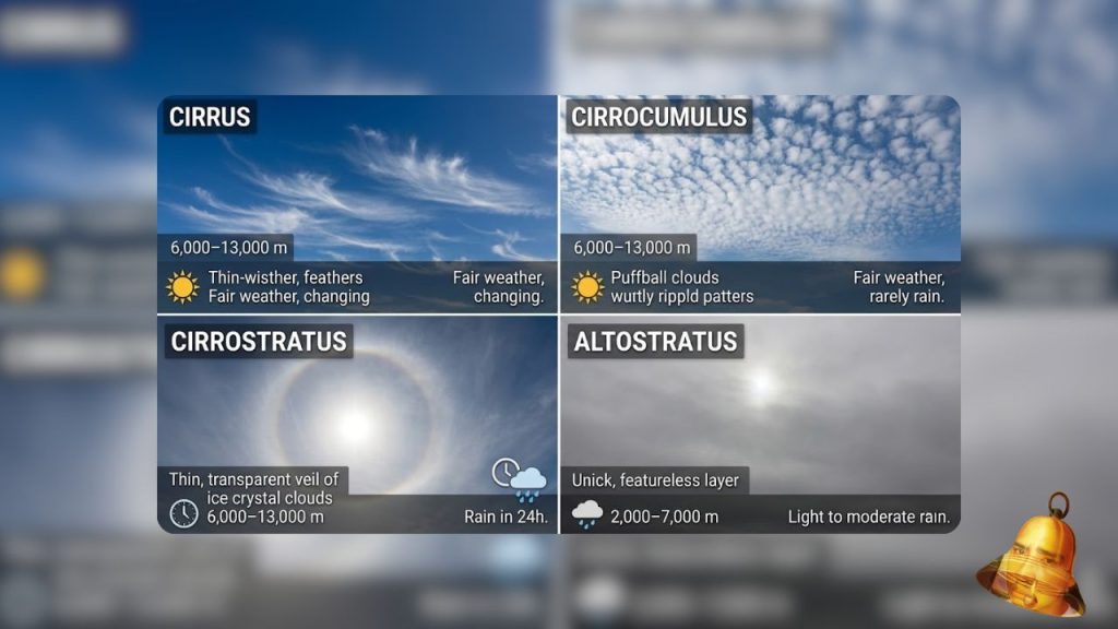
Many people often confuse cirrostratus with other cloud types. Here's a comparison:
| Types of Clouds | Main Features | Height | Weather Signs |
|---|---|---|---|
| Cirrus | Thin, like fiber | 6,000–13,000 m | Sunny weather, sometimes a sign of change |
| Cirrocumulus | In the form of small lumps | 6,000–13,000 m | Sunny weather, rarely rains |
| Cirrostratus | Thin, covering the sky, can form a halo | 6,000–13,000 m | Rain sign in 24 hours |
| Altostratus | Thick, covering the sky, gray | 2,000–7,000 m | Light to moderate rain |
How to Recognize Cirrostratus in Everyday Life
For the layman, recognizing cirrostratus clouds can be done with simple steps:
- Look at the sky : If it looks like a thin white sheet covering the sky, it's probably cirrostratus.
- Look for a halo : If there is a halo around the sun or moon, it is a strong sign of cirrostratus.
- Compare the shadows : If the sun can still cast a clear shadow even though it is covered by clouds, it is most likely cirrostratus, not altostratus.
The Importance of Recognizing Cirrostratus
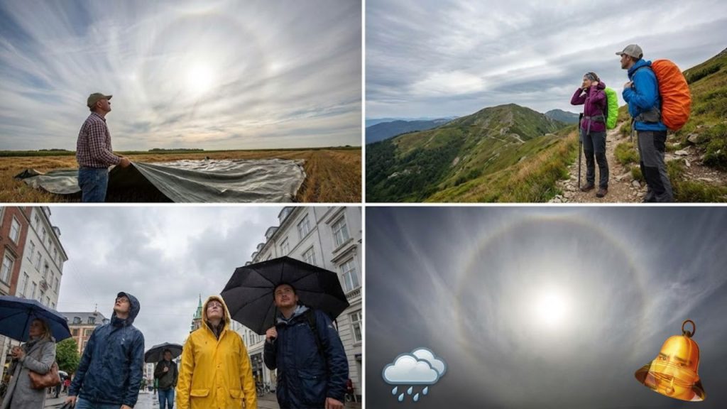
Knowing the signs of cirrostratus clouds can help us prepare for rain. For example:
- Farmers can anticipate rain for farming activities.
- Mountain climbers can be more alert if they see cirrostratus before the trip.
- The general public can prepare umbrellas or raincoats in advance.
Conclusion
Cirrostratus clouds are thin, high-altitude clouds that often appear like a white blanket across the sky. While they don't produce direct rain, their presence usually indicates that rain will arrive within 12–24 hours . Characterized by a halo around the sun or moon, these clouds are one of the natural signs we can use to predict the weather.
So, the next time you see a sky covered in thin clouds with a halo around the sun or moon, don't just marvel at its beauty. Remember that it could be a natural warning that rain is on the way .